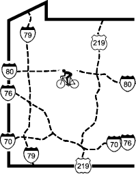
|
Redbank Valley Trail |
one moment while we fetch a trail picture
|
|
|
Redbank Valley Trail |
one moment while we fetch a trail picture
|
| Location | Allegheny River to Brookville with spur to Sligo | ||
| Trailheads | Armstrong Trail, Redbank Jct, Lawsonham, Climax Tunnel, | ||
| Length, Surface | Main line 42 miles crushed limestone, | ||
| Character | Little-used, rural, sun and shade, flat | ||
| Usage restrictions | No motorized vehicles | ||
| Amenities | Food, lodging | ||
| Driving time from Pittsburgh | 1 hours 16 minutes |
Because of the local geology, in many places the railroad was constructed with a very steep drop-off on the river side of the trail. This drop-off is steeper and has less vegetation than the typical rail trail in western Pennsylvania; extra caution is advisable in these areas.
The Redbank Valley Trail starts on the Armstrong Trail near the junction of Redbank Ck and the Allegheny River. This junction is MP63.5 on the Armstrong Trail and MP0.0 on the Redbank Valley Trail. From this junction, the trail closely follows Redbank Ck upstream. For the first mile or so there may be motorboats in the wide slackwater caused by the backwater of the Allegheny River.
There is an impressive covered bridge at MP1.0, note the size of the columns/beams.
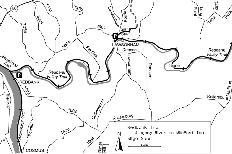
The trail is on a bench with a gradual climb from 25 feet above the creek at the mouth, to over 100 feet at Lawsonham (MP5.8). Once past the slackwater and power boats, the trail shares the isolated valley with the riffles of the creek, which is easy whitewater. The first 20 miles are remote except for a short stretch at Lawsonham and the Climax Tunnel. The forest in this area is relatively new growth. The densely growing trees are only 3 to 8 inches in diameter, but some stumps of 30 inches or more are visible in the woods. It was probably logged about 15 to 20 years ago.
At the Lawsonham trailhead (MP5.8), the Sligo Spur branches off and follows Wildcat Run north for 9 miles towards Sligo. This trail has a finished limestone surface. The trail has a gradual climb to about MP5 and then a gradual decent, with some of the grades as high as 3 percent.
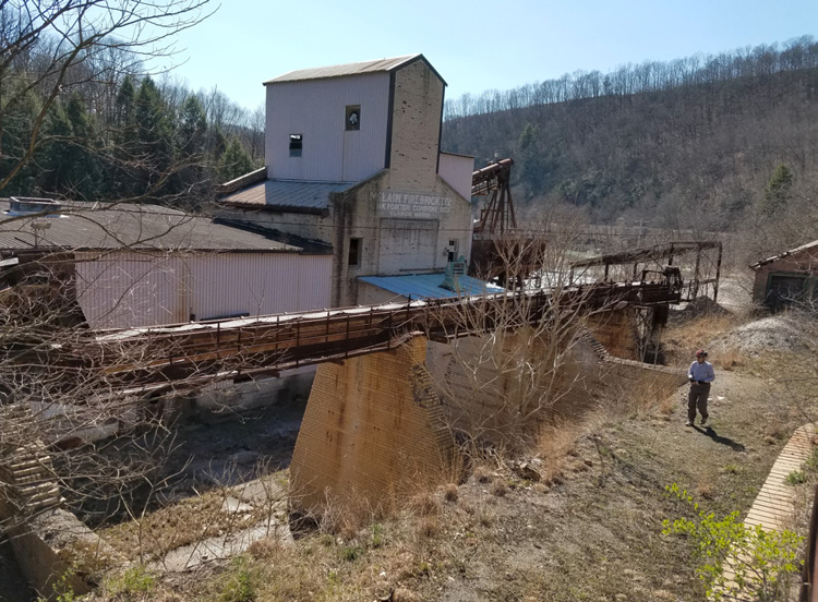
McLain Firebrick Plant
Just before MP8.0 an older railroad grade, unrideable, forks to the left and then turns back to cross the main trail and follow the contour around the ridge while the main trail continues straight ahead through the Long Point Tunnel (MP8.4). This tunnel is curved, so a light might be useful as light from the other end is not visible until about half way through. About 100 feet into the tunnel, the entrance stonework stops, and the tunnel is cut from natural rock for about 500 feet to within about 80 feet of the other end. Just after the trail emerges from the tunnel there is a substantial picnic pavilion and Adirondack shelter. The old grade rejoins the trail here.
The trail continues on a bench above the creek to MP14.8, where the remains of a firebrick factory lie for a tenth of a mile between the trail and the river. An interpretive sign just before the road explains the production process. The loading dock for the finished bricks is adjacent to the trail just after the road. After passing this industrial relic, the trail crosses Leatherwood Ck at MP14.9 and returns to woods along the creek. A sign at MP15.0 marks where an 1860 tornado passed. Notice the amount of recovery in the forest. Another substantial pavilion appears at MP15.5
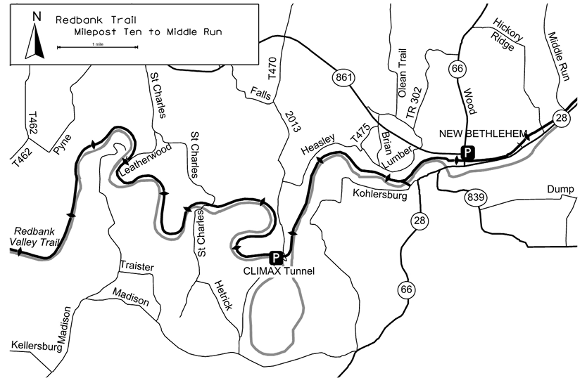
At MP17 the trail enters Climax Tunnel, which was paved in July 2018. This tunnel is also curved, so light from the far end is not visible until half way through. A good light is advisable.
Crushed limestone surface resumes at the east end of the Climax Tunnel (MP17.1). Just before MP19 a culvert blew out in a torentual rainstoom. A bridge was installed in the trail over the cuvert to provide safe passaege. Just past MP19 coke ovens are visible below the trail, explained by a nearby interpretive sign. At MP19.4 a short spur (0.1 miles) crosses Redbank Ck on the Trail Volunteers Bridge to meet Kohlersburg Rd. There is no trailhead here, just an access for local residents. Continuing on the main trail, at the west edge of town (MP20.1) a bear statue sports an impressive paint job. For the next mile and half the trail runs through New Bethlehem, adjacent to streets and parking lots. On the far end of the municipal parking lot an alleyway, directly south of the kiosk, connects to the main street providing access to food and services. A quarter-mile past the last street in town (MP21.0), a sculpture and Subway shop stand beside the trail.
At Middle Run Rd (MP21.5) the trail descends 25 feet steeply, crosses the road, and ascends just as steeply back to railroad grade where the railroad bridge has been removed.
Shortly after Middle Run the trail crosses route PA28 at MP22. The sight lines here are poor, the cars are traveling fast, and the drivers are paying attention to making the sharp bend in the road, so extra care is required at this crossing.
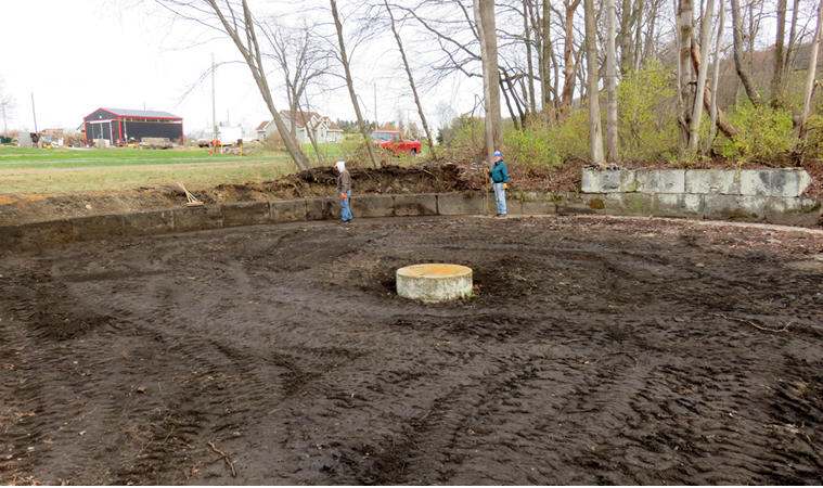
Remains of a turntable that was used to turn engines around © Sandy Mateer
The trail emerges from a low cut at MP22.5 to run alongside Alcola Cemetery and then for about 2 miles alongside PA28. The Redbank Historical Society has uncovered a railroad turntable (MP22.95) just before the sewer plant. The outer ring of stones and the center pivot stone is now visible. An owl sculpture seats on the pivot stone. Phillipston has a more complete example (See page 106).
Around MP24.5 the trail remains beside the creek as the road climbs away. East of the Mayport Rd (MP25.6) crossing, the trail is isolated to Heaveville (MP31.5), mostly in woods with occasional waterfalls. At MP30.2 the trail moves away from the creek as the creek takes a horseshoe bend. Behind the bench at MP30.3 and about 10 feet higher up are the remains of a stone retaining wall. This wall is best seen about 25 feet farther down the trail at a pipeline crossing. The wall continues along the trail, slowly descending to the trail grade. We speculate that this might a railroad siding for a logging operation.
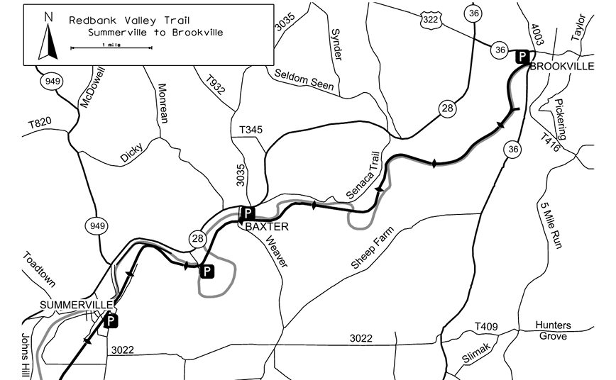
The trail cuts through a ridge (MP30.7), providing some coolness, and then crosses Redbank Ck (MP30.8). The Baker Hiking Trail (rachelcarsontrails.org/bt) comes off the hillside from the south at MP30.9, joins the trail for a half-mile, and leaves our trail to the north at the crossing of Strausser Rd (MP31.4). Emerging from the woods at MP32.8, the trail parallels Barr Rd to Yount Rd MP33.3, where it continues through farmland for half a mile to the trailhead in Summerville (MP34). In Summerville, the trail parallels streets in town. After Summerville the trail returns to the woods, crossing the Redbank twice over two long bridges within a quarter-mile (MP35.7). There is an impressive cut between Moore Rd and the second crossing (MP35.9). The trail association has installed thermometers just outside the entrance and inside the cut. During summer months, there is often a difference of 30 degrees. Just before the trail crosses Redbank Ck again (MP40.9), the Depot St Spur branches left to follow the creek into downtown Brookville. Just after crossing Redbank Ck, the railroad grade ends at the closed Brookville Tunnel (MP41). If the tunnel were open, the trail could cross 2 other bridges into Brookville. But this is a project for the future, so access to downtown Brookville is via the Depot St Spur that branched off just before the west end of the bridge.
Redbank Valley Trail - Oldest segment segment check 2019-Sep This page brought to you by the book