|
Redbank Valley Trail |
one moment while we fetch a trail picture
|
|
|
Redbank Valley Trail |
one moment while we fetch a trail picture
|
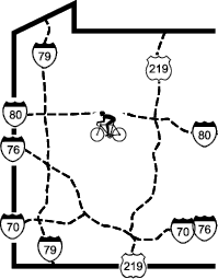
Vicinity: Directions begin at the interchange of PA28 and US422 west of Kittanning. To reach this point from Pittsburgh, go northeast on PA28.
East Brady trailhead on the Armstrong Trail: From vicinity north (intersection of PA268 and Kittanning Hollow Rd) turn right/north on Kittanning Hollow Rd and go 3.4 miles to PA68. Turn right/east on PA68. Follow PA68 about 2.6 miles, across the Allegheny River, into East Brady. PA68 is called Kellys Way and then turns left/southeast as Third St in East Brady. After the left turn on to 3rd St, go 6 blocks (counting the alleys) and turn right/southwest on Robinson St. Go to the end of Robinson St and turn left/south on Shady Shores Dr. Go four blocks and turn right/west into sewer plant parking. The trail continues down the private road part of Shady Shore DR, which allows bicyclist and hikers, but not cars
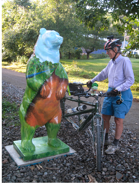
Statue at New Bethlehem
Redbank Junction trailhead: MP-0.1 This is a remote access points. To get to this access point you have to really want to get there. Take a GPS and a good map. It is easier to bike from East Brady (4.3 Miles).
Lawsonham trailhead: MP5.8 From the interchange of PA28 and US422, go east on US422/PA28 for 4 miles and take the PA28/PA66 north exit. Go 4.2 miles and turn left/north on Sloan Hill Rd. Go 2.4 miles and turn right/east at the first “T”, then 400 feet later turn left/north at the second “T” on to SR1031. Go 0.4 miles and bear left/north at the “Y” on SR1031. Go 2.9 miles and in Templeton turn left/west on 4th St. Ignore the alley and turn right/north on Clay St. When leaving town, turn left/north on SR1003. Go 4.0 miles and turn left/west and then right/north to stay on Lawsonham Rd/SR1003. Go 3.3 miles and turn left/west in Lawsonham after crossing Redbank Ck. Go 0.3 miles to the trailhead on the right.
T-468 , Leatherwood Station Rd. MP14.8 Lat. 41.003 / Long. -79.4107 << Driving directions to Leatherwood Station >>
Climax Tunnel, west side trailhead: MP17 From the interchange of PA28 and US422, go east on US422/PA28 for 4 miles and take the PA28/PA66 exit. Go 15.6 miles, and just before entering Distant make a very sharp left hand turn on to Kohlersburg/Madison Rd. Go 1.6 miles and turn right/north on Hetrick Rd/T582. Go 0.1 miles and take a slight right/northeast on Climax Rd. Go 1.2 miles, cross the bridge, and the trail/parking/tunnel will be on the left side of the road.
New Bethlehem trailhead: MP20.2 From the interchange of PA28 and US422, go east on US422/PA28 for 4 miles and take the PA28/PA66 exit. Go 18.6 miles to Lafayette St in New Bethlehem, turn left/north at the stoplight. Go two blocks to Arch St and turn right/east. Go half a block to the municipal parking lot. The trail is on the left side of Arch St. There is some parking alongside the trail and there is parking in the metered lot with a sign that says “free parking”.
Hawthorn trailhead: MP22.5 From the interchange of PA28 and US422, go east on US422/PA28 for 4 miles and take the PA28/PA66 exit. Go 22.5 miles to Walker Flat Rd in Hawthorn and turn right/southeast. Go 300 feet, cross the trail and turn left/north east. Park alongside the trail, not on it. Do not park inside the soccer field.
Potter Field Trailhead MP24 From the interchange of PA28 and US422, go east on US422/PA28 for 4 miles and take the PA28/PA66 exit. <<Go 22.5 miles>> to Potter Field courts. Do not park inside the fence, but by the trail near the buildings.
Mayport trailhead: MP25.6 From the interchange of PA28 and US422, go east on US422/PA28 for 4 miles and take the PA28/PA66 exit. Go 24.2 miles to SR536 and turn right/south on Mayport Rd. Go 0.7 miles, trail parking is before crossing the river.
Heathville Rd trailhead: MP31.5 From the interchange of PA28 and US422, go east on US422/PA28 for 4 miles and take the PA28/PA66 exit. Go 27.4 miles to Macadam Rd and turn right/east. Go 1.4 miles and turn left /northwest on Strausser Rd. Go 0.4 miles and turn right/east to stay on Strausser Rd. Go 1.3 Miles, cross the creek and park on the right.
Summerville trailhead: MP34 From the interchange of PA28 and US422, take the PA28/PA66 exit. Go 31.2 miles to just past the brick plant to Carrier St in Summerville. Turn right/south on Carrier St. Go 0.2 miles to the bridge where the street name becomes State St. Continue 0.2 miles on State St to trail parking on the left, just before the trail.
Moore Rd trailhead: MP35.7 From the interchange of PA28 and US422, go east on US422/PA28 for 4 miles and take the PA28/PA66 exit. Go 32.8 miles to Moore Rd at the top of a hill. Turn right/south on Moore Rd and go 0.2 miles to the trail.
Baxter trailhead: SR 3003/9675 Mt. Pleasant Road, Corsica Lat. 41.1324035 / Long. -79.1531138 << get driving directions to Baxter>>
Brookville, Depot St (eastern) trailhead: MP41.8 From the interchange of PA28 and US422, go east on US422/PA28 for 4 miles and take the PA28/PA66 exit. Go 37.4 miles to S Main street and turn right/east. Go 0.8 miles to Madison Av, just before the junction with US322, and turn right/east. Go one long block (0.2 miles) and turn right/south on PA36/S White St. Go 200 feet and just before crossing the creek turn right/west. Go another 200 feet and turn left/southwest into parking behind Brookville Lumber.
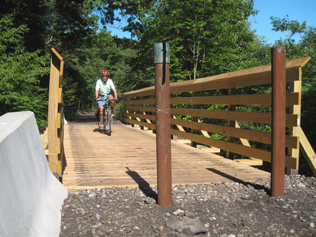
Coder Run Bridge
Redbank Valley Trail - Access Points
Vicinity: Directions begin at the interchange of PA28 and US422 west of Kittanning. To reach this point from Pittsburgh, go northeast on PA28.
East Brady trailhead on the Armstrong Trail: From vicinity north (intersection of PA268 and Kittanning Hollow Rd) turn right/north on Kittanning Hollow Rd and go 3.4 miles to PA68. Turn right/east on PA68. Follow PA68 about 2.6 miles, across the Allegheny River, into East Brady. PA68 is called Kellys Way and then turns left/southeast as Third St in East Brady. After the left turn on to 3rd St, go 6 blocks (counting the alleys) and turn right/southwest on Robinson St. Go to the end of Robinson St and turn left/south on Shady Shores Dr. Go four blocks and turn right/west into sewer plant parking. The trail continues down the private road part of Shady Shore DR, which allows bicyclist and hikers, but not cars
Statue at New Bethlehem
Redbank Junction trailhead: MP-0.1 This is a remote access points. To get to this access point you have to really want to get there. Take a GPS and a good map. It is easier to bike from East Brady (4.3 Miles).
Lawsonham trailhead: MP5.8 From the interchange of PA28 and US422, go east on US422/PA28 for 4 miles and take the PA28/PA66 north exit. Go 4.2 miles and turn left/north on Sloan Hill Rd. Go 2.4 miles and turn right/east at the first “T”, then 400 feet later turn left/north at the second “T” on to SR1031. Go 0.4 miles and bear left/north at the “Y” on SR1031. Go 2.9 miles and in Templeton turn left/west on 4th St. Ignore the alley and turn right/north on Clay St. When leaving town, turn left/north on SR1003. Go 4.0 miles and turn left/west and then right/north to stay on Lawsonham Rd/SR1003. Go 3.3 miles and turn left/west in Lawsonham after crossing Redbank Ck. Go 0.3 miles to the trailhead on the right.
T-468 , Leatherwood Station Rd. MP14.8 Lat. 41.003 / Long. -79.4107 << Driving directions to Leatherwood Station >>
Climax Tunnel, west side trailhead: MP17 From the interchange of PA28 and US422, go east on US422/PA28 for 4 miles and take the PA28/PA66 exit. Go 15.6 miles, and just before entering Distant make a very sharp left hand turn on to Kohlersburg/Madison Rd. Go 1.6 miles and turn right/north on Hetrick Rd/T582. Go 0.1 miles and take a slight right/northeast on Climax Rd. Go 1.2 miles, cross the bridge, and the trail/parking/tunnel will be on the left side of the road.
New Bethlehem trailhead: MP20.2 From the interchange of PA28 and US422, go east on US422/PA28 for 4 miles and take the PA28/PA66 exit. Go 18.6 miles to Lafayette St in New Bethlehem, turn left/north at the stoplight. Go two blocks to Arch St and turn right/east. Go half a block to the municipal parking lot. The trail is on the left side of Arch St. There is some parking alongside the trail and there is parking in the metered lot with a sign that says “free parking”.
Hawthorn trailhead: MP22.5 From the interchange of PA28 and US422, go east on US422/PA28 for 4 miles and take the PA28/PA66 exit. Go 22.5 miles to Walker Flat Rd in Hawthorn and turn right/southeast. Go 300 feet, cross the trail and turn left/north east. Park alongside the trail, not on it. Do not park inside the soccer field.
Potter Field Trailhead MP24 From the interchange of PA28 and US422, go east on US422/PA28 for 4 miles and take the PA28/PA66 exit. <<Go 22.5 miles>> to Potter Field courts. Do not park inside the fence, but by the trail near the buildings.
Mayport trailhead: MP25.6 From the interchange of PA28 and US422, go east on US422/PA28 for 4 miles and take the PA28/PA66 exit. Go 24.2 miles to SR536 and turn right/south on Mayport Rd. Go 0.7 miles, trail parking is before crossing the river.
Heathville Rd trailhead: MP31.5 From the interchange of PA28 and US422, go east on US422/PA28 for 4 miles and take the PA28/PA66 exit. Go 27.4 miles to Macadam Rd and turn right/east. Go 1.4 miles and turn left /northwest on Strausser Rd. Go 0.4 miles and turn right/east to stay on Strausser Rd. Go 1.3 Miles, cross the creek and park on the right.
Summerville trailhead: MP34 From the interchange of PA28 and US422, take the PA28/PA66 exit. Go 31.2 miles to just past the brick plant to Carrier St in Summerville. Turn right/south on Carrier St. Go 0.2 miles to the bridge where the street name becomes State St. Continue 0.2 miles on State St to trail parking on the left, just before the trail.
Moore Rd trailhead: MP35.7 From the interchange of PA28 and US422, go east on US422/PA28 for 4 miles and take the PA28/PA66 exit. Go 32.8 miles to Moore Rd at the top of a hill. Turn right/south on Moore Rd and go 0.2 miles to the trail.
Baxter trailhead: SR 3003/9675 Mt. Pleasant Road, Corsica Lat. 41.1324035 / Long. -79.1531138 << get driving directions to Baxter>>
Brookville, Depot St (eastern) trailhead: MP41.8 From the interchange of PA28 and US422, go east on US422/PA28 for 4 miles and take the PA28/PA66 exit. Go 37.4 miles to S Main street and turn right/east. Go 0.8 miles to Madison Av, just before the junction with US322, and turn right/east. Go one long block (0.2 miles) and turn right/south on PA36/S White St. Go 200 feet and just before crossing the creek turn right/west. Go another 200 feet and turn left/southwest into parking behind Brookville Lumber.
Coder Run Bridge